Trail Walking Le Mesnil-Eury - Mesnil Eury - Photo
 guy50880
guy50880

User

© OpenStreetMap contributors
Length
Length
7.3 km
Max alt
Max alt
44 m
Uphill gradient
Uphill gradient
64 m
Km-Effort
Km-Effort  
8.2 km
Min alt
Min alt
6 m
Downhill gradient
Downhill gradient
64 m
Boucle
Boucle
Yes
Creation date :
2019-09-19 12:23:20.943
Updated on :
2019-09-19 14:14:56.819

(0 Reviews)

Walking
Walking
1h41
Difficulty : Very easy

Scan this QR Code to open this trail in the SityTrail application

FREE GPS app for hiking

Logo SityTrail SityTrail

IGN / Geographical institutes

Download SityTrail from the App Store Download SityTrail from Google Play

Logo SityTrail SityTrail World

The world is yours!

Download SityTrail from the App Store Download SityTrail from Google Play Download SityTrail on Huawei AppGallery

About

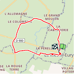
Trail Walking of 7.3 km to be discovered at Normandy, Manche, Le Mesnil-Eury. This trail is proposed by guy50880.

Description

Facile

Elevation profile

Positioning

Country:
France
Region :
Normandy
Department/Province :
Manche
Municipality :
Le Mesnil-Eury
Location:
Unknown
Start:(UTM)
628566 ; 5445790 (30U) N.

Trails nearby

Trail Walking Hauteville-la-Guichard - Pédestre - Promenade et Randonnée Sur la trace des Tancrède - Photo
Walking
neoroll44

Walking

Medium
Hauteville-la-Guichard, Normandy, Manche, France
20 km | 24 km-effort
5h 30min
Yes
Trail Walking Hauteville-la-Guichard - Sur la trace des Tancrède - Hauteville la Guichard - Photo
Walking
tracegps

Walking

Difficult
(1)
Hauteville-la-Guichard, Normandy, Manche, France
21 km | 25 km-effort
3h 30min
Yes
Trail Walking Remilly-les-Marais - Le Mesnil Vigot - Photo
Walking
guy50880

Walking

Very easy
Remilly-les-Marais, Normandy, Manche, France
10 km | 11.5 km-effort
2h 32min
Yes


Close
My subscriptions